
Katrina was so huge, she took up nearly the whole Gulf of Mexico. Camille was a far smaller storm, but much more intense storm.
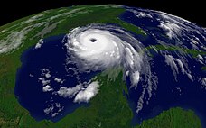 This is a different satellite view of Katrina in the Gulf of Mexico.
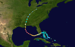
This is Katrina's Track from the Atlantic Ocean through the Caribbean Sea, over Florida, into the Gulf of Mexico, and it's final landfall 15 miles east of New Orleans.
The track of Hurricane Camille, one of only three category 5 storms to make landfall in the United States, isn't that similar to Katrina. (See next image). The other 2 category 5 hurricanes to hit the U.S. were Andrew in August, 1992 and Wilma in October, 2005.
 This is Hurricane Camille's Track through the Gulf of Mexico. It made landfall on August 17, 1969 very near the mouth of the Mississippi River with devastating consequences.
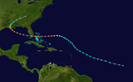
Katrina's track follows the track of Hurricane Andrew (right) more closely than that of Camille.
Hurricane Andrew struck during August 1992, making landfall as a category 5 hurricane at Homestead, FL, just south of Miami. It proceeded into the Gulf of Mexico and made landfall again 20 miles west southwest of Morgan City, Louisiana, with a wind speed of 115 mph (a category 3 hurricane).
Even though Hurricane Katrina was a category 5 storm until it began to make landfall and fell rapidly to a category 3 storm, it killed more people and did more damage than the three category 5 hurricanes that hit the U.S.
Because of the storms like Hurricane Katrina and Hurricane Betsy (1965), the Saphir-Simpson Hurricane Scale is beginning to be called into question for its ability to predict storm damage and deaths. The fact that weaker storms did extensive damage and killed more people than some category 5 storms is evidence that more research is needed to make the SSHS a more accurate predictor of deaths and damage.
Here is a book of many more pictures of Hurricane Katrina and her aftermath: Hurricane Katrina Picture Book
References: Photos are from NASA satellites and NOAA Weather Satellites. Storm Tracks are from the National Hurricane Center.
No comments:
Post a Comment